For the first time on the trail, I'm not sure what I should do.
Today was my first full day back on the trail and it was extremely disappointing. For starters, I was planning to hammer out 25 miles. With a few days of rest and updated gear, I figured it wouldn't be too difficult. Everything started out okay, but around lunchtime things deteriorated. After I finished eating and was back on the trail, I started to feel the early signs of a blister on the ball of my right foot. This is very worrisome to me. After 1150 miles, I should be past this stuff. Then, about 13 miles into my day, I elected to go through a small snowfield instead of around it. After making it nearly all the way across, I slipped and shot down the slope about 10 feet into a nice, big mud puddle. Awesome. My entire right side was covered in mud. My clothing is synthetic so it didn't absorb any of it, but it was still a mess. There was no water nearby (the mud was from snowmelt) so I just kept hiking and eventually made it to Donner Pass (near I-80). There is a Trail Angel here named Bill so I decided to give him a call and see if I could clean myself up. He was very accommodating and so that is where I am now. That's the good news. The bad news is that I still have what could be the beginning of some serious foot issues. I may go back down to Reno tomorrow to see if I can't get better shoes or insoles. The alternative is I try to tough it out and risk long-term injury. I just don't know what to do.
Thursday, July 23, 2009
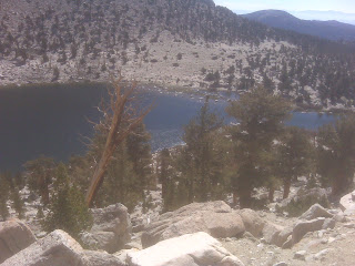
Another Lake Tahoe View

Wednesday, July 22, 2009
Day 79
I began the day by loading up the rental car with six boxes to be mailed. Three contained food and were being sent to various spots up the trail. One was a box of stuff I no longer needed on the trail (for example, my bear canister) sent to my parents, a box of stuff for Adrienne going back east, and my bounce box. Like everything else these days, it wasn't cheap!
On the way to the post office I stopped at Red Hut (again) for breakfast. FYI, I had the strawberry waffle breakfast (including eggs, bacon or sausage, and biscuits with gravy) for the fifth day in a row. Trust me when I say it was heaven on a plate!
After the post office, I returned the rental car (sniff, sniff) and focused on getting back on the trail. One of the waitresses at Red Hut offered to give me a ride back to the trailhead (thanks Diane!), but I ended up getting a ride with another guy who was also staying at the hotel. His daughter was also hiking the PCT and he was there helping her with logistics so it worked out perfectly! So around 1:30 we headed out and after some conversation with other hikers at the trailhead, I was back at it by 3:30. Unfortunately, my legs didn't feel as nearly as fresh as I was expecting them to. So the going was slow and achy, but I ended up getting about 11 miles under my belt before it got dark. My goal is to get to the halfway point (in terms of mileage) on the trail before the end of the month and I've got my work cut out for me! I'm currently at 1138.2 and need to get to 1331.5--nearly 200 miles--in nine days. My body already hurts just thinking about it. Hopefully I'll get off to a good start tomorrow with a 25-mile day. That would be very helpful!
Lake Tahoe View

Days 74 - 78
The stay in South Lake Tahoe was everything I had been hoping for in the weeks leading up to it--relaxing, restful, and just a lot of fun. I started out on Friday, July 17, by getting a rental car and then driving the hour or so to Reno to pick up Adrienne. It was so good to see her! Before leaving Reno we made a stop at In-n-Out and then REI so that I could pick up some replacement gear. She was a great sport about it. I had very good luck at REI and they replaced my backpack free of charge because a crack was starting to develop in the internal frame. They also replaced my pants because of some stitching that was coming out. So when I hit the trail again, I had new socks, shoes, backpack, and pants. I felt like a new man! We also made a stop at Costco on the way back to Tahoe so that I could pick up some food for my hike. It tends to be pretty expensive near the trail so I was buying in bulk and then shipping it along to a few resupply spots.
Over the course of the next 3+ days, we went to the beach, ate VERY well (go to the Red Hut Cafe whenever you are in Tahoe!), took a drive around part of the lake, and even rented a boat for part of the afternoon. It was way too much fun and it went by way too fast. Before I knew it, it was Tuesday and I had to drive her back to the airport and start thinking about getting on the trail again.
I elected to stay an extra day in Tahoe to get my resupply business done. So after running errands and trying to figure out the best resupply strategy for me, I started packing things up. By the time I was done, it was 2 am this morning and I was exhausted. My hope was to get a ride to the trail around noon or so, but I hadn't yet been able to find one.
Day 73
Today I was on a mission to get to Barker Pass, where I was planning to head east to Lake Tahoe for a break with Adrienne for a few days. To be honest, I didn't notice a whole lot of the views along the way because I was just trying to get there as quickly as possible to meet my friend Stacie at 7 that evening for a ride back down to civilization.
I ended up getting there about a quarter to 6 and just relaxed, savoring the fact that I didn't have anywhere more to go before my first and only real vacation during my hike. A few minutes after 7, Stacie showed up and I was on my way! She informed me that Tom and Cobie had offered up some floor space at their motel room for me if I was interested. I definitely was and eagerly washed the dirt off before grabbing dinner at Subway (fit for a king, mind you) and preparing for Adrienne's arrival.
Day 72
(Originally written on Wednesday, July 15)
Today definitely ranked high on the frustration chart and I'm glad it is over.
We got up and were on the trail by 6 this morning. Tom and Cobie were splitting off at Highway 50 to head into South Lake Tahoe for resupply. I was going to continue on to Echo Lake Resort to get breakfast, then lunch, before continuing on for another 32 miles to Barker Pass. All went according to plan and I even got to the resort by 9:45 after hiking 10.5 miles. The only problem was the "resort" had no restaurant. So I was stuck eating various forms of junk food instead of a good, hot meal I had my heart and stomach set on.
After gorging myself with calories, I eventually got back on the trail around 2 pm with the goal of at least 10, and maybe 15, miles. The first 7 miles were fine, but then I got to Aloha Lake which had loose, baseball-sized chunks of granite as the pathway. Of all the trail surfaces, I hate this one the most. Every step you take feels as if it could be your last one before a broken ankle, never mind the pain of chronic blisters! This surface went on for several miles and I knew that 15 miles was no longer possible, so I set my sights on Dicks Pass--the last point on the PCT above 9000'. I figured I'd get close enough to it to tackle it first thing in the morning. So I hiked on the granite baseballs for a couple more miles around lakes that were mosquito-free due to the light wind that was blowing. I figured if the wind was blowing down here, surely it would be blowing at higher elevation...right? Wrong. I got to the point where I planned to camp and the mosquitos were the worst I'd seen all day. Strike three. So I kept walking, because I did not want to deal with them. And I walked. And walked. Finally, when I had nearly got to Dicks Pass, I found a rare piece of flat ground and just decided it would have to do. And of course, the mosquitos were still there. So here I am up on the side of a mountain, being harassed by mosquitos, low on water, and feet that are even more tired than usual because of granite baseballs. I can't wait for South Lake Tahoe.
Day 71
(Originally written on Tuesday, July 14)
After today's 24 miles, I'm left with a mere 10.5 to go before Echo Lake, my next town stop. In case you didn't know by now, town stops are a big deal to the PCT hiker. We are unable to carry enough food to compensate for the calories we burn, which is why most of us lose weight. So anytime we get to a town, we generally settle in for a substantial feast. I am no exception to this rule and so I'm planning--along with Tom and Cobie, who I've reconnected with--to be on the trail by 6 am tomorrow in order to get to Echo Lake while breakfast is still being served. Assuming I'm successful, then I'll stick around for lunch too! No matter how much I'll eat, I'll likely have it burned off before the end of the day. I'll also grab enough food to get me another 32 miles up the trail, where I'll head east to Lake Tahoe and some time off. Considering how tired my feet (and the rest of my body) are and how long it's been since I've seen Adrienne (nearly three months), you can guess that I'm counting down each mile!
As for today's hike, we were on the trail by 6:30 and had an uneventful day consisting of the usual ups and downs, various creek crossings, and beautiful views. In the afternoon we came to Carson Pass, named for Kit Carson. There the folks at the information center gave us water, Oreos, and bananas. It was awesome. Once we left in the late afternoon, we were planning to go another 7ish miles to Showers Lake. Soon after a short climb following Carson Pass came the best hiking of the trail yet. It was a flat, winding trail through a meadow without mosquitos! It was so nice and such a change from what we've grown accustomed to recently. Of course it was short-lived and soon we were faced with a steeper-than-expected climb up to Showers Lake where we are now. Even more disappointing was the re-emergence of the voracious mosquitos. Even though they are small, they definitely have the capacity to take the luster off a good day.
Day 70
(Originally written on Monday, July 13)
I'm not quite sure why, but it has been more difficult to get up in the morning with each successive day. I'm not sure if it is because I know I can do more miles in less time or if I'm just tired. I think it is mostly because I'm tired, and not just sleepy tired...I mean tired to the bone. I can feel it in my joints, muscles, everywhere. Even on the tops of my feet. The break in Tahoe couldn't have come at a better time. Some rest, new shoes (my current pair is being held together by duct tape...oh no...flashbacks!), new socks...I'll feel like a new man.
So, despite the fatigue I was still able to push out 20 miles, which brings my total to 99 miles for the last four days. Tomorrow will be another 25ish day because I'll be hiking with Tom and Cobie--a couple of speed demons on the trail. That would be fantastic because then that would only leave me about 10 miles to get to Echo Lake on Wednesday!
Day 69
(Originally written on Sunday, July 12)
I was able to salvage what looked like was going to be a day of minimal mileage. After yesterday's big mileage, I knew that I was going to feel it. First though, I allowed myself to sleep in. I wasn't on the trail until 9:30, but I wasn't feeling too stressed about getting big miles either. I wanted to get around 20 just so I felt like I had a good day. In the morning, however, my legs and lungs just weren't cooperating and I was laboring for everything. Eventually I did make it about 9 miles before stopping for a late lunch. Then, in the afternoon, I felt great! The miles were flying by and I was making great time. So by the time I quit for the day, I had put in another 22 miles. That's 79 miles in three days! The afternoon terrain was awesome...some steep ups and downs, but mostly just medium-grade inclines and declines. One thing worth noting is that I'll no longer be above 10,000' on the PCT after today. When I left that altitude this morning, it was the last time going northbound. It was fun while it lasted, but I'm not going to miss it!
I was able to salvage what looked like was going to be a day of minimal mileage. After yesterday's big mileage, I knew that I was going to feel it. First though, I allowed myself to sleep in. I wasn't on the trail until 9:30, but I wasn't feeling too stressed about getting big miles either. I wanted to get around 20 just so I felt like I had a good day. In the morning, however, my legs and lungs just weren't cooperating and I was laboring for everything. Eventually I did make it about 9 miles before stopping for a late lunch. Then, in the afternoon, I felt great! The miles were flying by and I was making great time. So by the time I quit for the day, I had put in another 22 miles. That's 79 miles in three days! The afternoon terrain was awesome...some steep ups and downs, but mostly just medium-grade inclines and declines. One thing worth noting is that I'll no longer be above 10,000' on the PCT after today. When I left that altitude this morning, it was the last time going northbound. It was fun while it lasted, but I'm not going to miss it!
10,000'

Day 68
(Originally written on Saturday, July 11)
When I started hiking this morning, I was at Mile 987.6 (Wilmer Lake). When I finally made camp just across Sonora Pass (Highway 108), I was at Mile 1018.5--a total distance of 30.9 miles! This was easily my longest day on the trail thus far and my first 30+ mile day. Suffice it to say that I am extremely proud of myself, especially because I did it in the Sierras, which isn't generally very easy terrain. Three benefits that will help immediately are that 1) I should now be out of the worst mosquito country, 2) I have only a short climb tomorrow back up to 10,000' for the last time on the PCT before dropping down a few thousand feet, and 3) I'm past a very windy section that looked strangely like terrain the Mars Rover has been on. I'm sure that there will be times that I miss the higher elevations, but I'm ready to be done with them!
In other news, I crossed the 1,000-mile mark! It doesn't feel like I've actually made it that far, although my feet feel differently. I'm confident that the next 1,000 miles will go better and faster than the first 1,000 miles. At least I'm hoping! To make that happen I've got to get to the Tahoe area in the next five days, which wouldn't be a problem except that my shoes are (sort of) falling apart and most of my socks have holes in them. So when I get to Tahoe, the first order of business will be to pick up Adrienne from the airport in Reno (she's visiting me for a few days), then go to In-n-Out where I'm going to eat multiple burgers, then to REI where I will upgrade some of my clothes that have taken an absolute beating through the Sierras. It's going to be wonderful.
After today's long miles and yesterday's 26-mile day, tomorrow figures to be a smaller day. I'm not sure how many miles I'll go for, but I'm pretty sure my feet will have a say in that because they are pretty sore and tired right now.
1000 Miles!

Days 66 and 67
Details from these days are sketchy because a mishap that occurred on the trail late in the day on Thursday, July 9, prevented me from documenting the days. I was crossing a creek, which is a common practice on the trail, and hopping from one rock to the next. I made it all the way across to the last questionable rock and when I stepped on it, it wobbled. I slipped, thought I regained my balance, and just kept going down. The creek wasn't very deep yet somehow 3/4 of me and my gear got wet. It was the capstone to a very frustrating day--the first day that I really didn't want to be on the trail, in fact.
I ended up making camp right there in Matterhorn Canyon after only doing 12 miles. The rest of the afternoon was spent drying out my gear. Things became even more complicated when I left my already-falling-apart shoes too close to the fire and the side of one melted slightly. This made my shoe fit tighter and over time created even more foot pain for me until I arrived in South Lake Tahoe just over a week later.
The next day was uneventful, thankfully. It was a 26-mile-day because I was trying to make up time. It was also a very rugged day, going up and down four separate minor passes that were all quite steep. There were also a few creek crossings which I'm happy to report did not cause me any more issues of an unexpected nature!
Tuesday, July 21, 2009
Day 65
(Originally written Wednesday, July 8)
It was really hard to get up this morning because of the cold weather. I ended up sleeping in until 9:30--an unheard of time for me! I think part of the reason was that I was using both my regular foam mattress pad as well as my very light air mattress that was in my bounce box.
After breakfast, I went about the business of procrastinating. After hiking with a nearly empty (with respect to food) pack for several days, the thought of reloading for a 7- or 8-day hike without resupply was discouraging. Seeing a lot of other hikers enjoying all the junk food available to us didn't help matters. Eventually I did take down my tent, bought my groceries, and shipped my bounce box. By the time I actually got back on the trail, it was nearly 5:30. I cranked out six miles relatively quickly and made camp at a nice campground called Glen Aulin. The Tuolumne River is nearby complete with waterfall.
Tomorrow is going to be a grind with mostly ups and some downs. Soon I'll probably be wishing for some steeper ups and downs, but with a full pack, the task sounds daunting at the moment.
Day 64 - Tuolumne Meadows
(Originally written Tuesday, July 7)
My arrival at Tuolumne Meadows (TM) today marked the official end to the longest section of the trail according to my guidebook--a distance of nearly 200 miles. Despite the fact that it has been some of the most magnificent and awe-inspiring scenery, I'm not all that disappointed to be moving along. A person can only handle so much beautiful scenery before he or she gets overloaded. I gave up trying to capture moments with a camera because it just wasn't possible. It was a five-sense thing, not just a sight thing. Still, despite it being very hard work to make it through the High Sierras, I enjoyed it tremendously. After every climb, I could look down on the valleys below and know that I earned each view.
At Donohue Pass today, I was at the last point on the trail that is over 11,000' and it was bittersweet. High elevation has its advantages--solitude is usually one of them, but not today. There was a lot of foot traffic which kind of took away from the experience. But it was good nonetheless. Soon I'll be leaving 10,000' for good as well, and once I hit the Oregon border, I won't go over 8,000' for the remainder of my journey. It hardly seems possible.
Tomorrow is a resupply day. I've got about two days worth of food and need seven to make it to Echo Lake near Lake Tahoe. The store here at TM is a little lacking right now but they are expecting a big shipment tomorrow. So despite my urge to keep moving, I may be forced to sit for a little bit. But that definitely has its advantages as well. Sometimes my body needs the breaks even when I don't realize it. So for the time being, I'm showered and have clean laundry thanks to the generosity of one of the resort employees (shhh...I'm not actually a guest!). Hopefully I'll be fully resupplied tomorrow early afternoon and ready to hit it hard.
Day 63
(Originally written Monday, June 6)
Reds Meadow was much too difficult to leave, especially after having the french toast at the cafe. It was so good. Nevertheless, I was on the trail by 10:30. Since it was 35 miles to Tuolumne Meadows--more than one day of hiking but less than two--I really wasn't all that motivated to get an early start. I was chatting with a couple other hikers in the cafe and during the course of conversation my goal of getting to Tuolumne Meadows came up. A John Muir Trail (JMT) hiker expressed skepticism that I'd be able to make it. Silly section hiker! I've only got about 15 miles to go after today.
The hike itself wasn't all that interesting. More or less a couple of straight lines through a couple canyons. But I did get to see the Devil's Postpile, an interesting volcanic rock structure, early in the hike. I also got to hike part of the Ansel Adams Wilderness, which is where I am now. Around 1 pm I bumped into a pleasant group of families who were backpacking with their kids and they were so friendly! They offered me bagels, peanut butter, and honey...score! They were interested to hear about my hike. In fact, the Sierras have been full of southbound hikers who have been interested in my hike. Seeing the look on their face when I say "Canada" in response to their question of "Where are you headed?" is priceless!
So tonight I'm camped at Island Pass--so named for Thousand Island Lake below it. The weather is cold and windy but I'm cozy in my sleeping bag and tent. This may very well be the last time I camp above 10,000'. And when I go up and over Donohue Pass tomorrow, it will be the last time I'm above 11,000' while on the PCT. It hardly seems possible.
Two more quick notes. The first is that my hike was the feature item in the Livestrong grassroots fundraising letter that went out over email on June 24. Second, the Tour de France is currently going on. Don't forget to root for Lance!
Ansel Adams Wilderness

Day 62 - Reds Meadow
(Originally written Sunday, July 5)
Tonight I have cell service for the first time since just outside of Tehachapi--nearly 300 trail miles earlier! When I finally arrived at Reds Meadow (close to Mammoth Mountain) this evening after racing to get here before the cafe closed, I turned on my phone and...surprise! I've got a lot of emails to sift through...most of it junk, unfortunately.
After bushwhacking our way through the darkness last night in search of a hot springs that allegedly existed, we finally got to a suitable camp well into the night. This morning we slept in--by hiker's standards that means after 8--and were awakened by one of the guys in our group letting us know that he found the springs. So after a good, long soak, I was ready to hit the trail. I only made it about 12 miles to Reds Meadow, but I couldn't resist staying where I could get a hot meal and a free hot shower from more hot springs! So here I am and I've even got cell service (although this likely won't get posted until later because I'm trying to do this chronologically).
After downing an overpriced double cheeseburger at the restaurant, I had peach pie a la mode as well. I'm planning to grab a substantial breakfast tomorrow before heading out to Tuolumne Meadows--a two-day journey.
It's hard to believe that I'm at Mile 906.6 and more than a third done with the trail! The miles, in a very strange way, seem to be really flying by--as much as they can at 2.5 mph, anyway.
So it is definitely nice to be back in civilization for the time being. And although I don't expect it to last all that long, I do expect the coverage to be better than it has been. After all, it's not that hard to improve upon that which didn't exist!
Days 60 and 61
(Originally written on Saturday, July 4)
We reached the ferry landing on Edison Lake about two hours before sunset two nights ago and passed the time by fishing (no luck), making mental lists of what we needed to do at Vermilion Valley Resort (VVR), and dreaming about all the real food we were going to eat. The ferry didn't come until the next morning at 9:30ish so we had plenty of time!
When the ferry did come the next day we were ready to roll. First thing we did was get to the restaurant while they were still serving breakfast. I had my two favorite things: biscuits and gravy, and a breakfast burrito. Hot coffee topped it all off. I was in heaven. Shortly after that, I went to work removing the 11 days of grime I had accrued. Then I ate some more. Then I did laundry. And then I ate some more. It was heaven. Do you see a pattern?
This morning I made sure all my gear was good to go back out and crammed all my food for the 3-4 day journey to Tuolumne Meadows into my bear canister. Then I had a big breakfast before heading back out onto the ferry at 9 so that I could get a good day of hiking in.
With a pack that wasn't nearly as heavy as when I left Kennedy Meadows, I was feeling good. By 1:30 and after seven miles, I had climbed all the way back up to 10900' after starting under 8000'. I rewarded myself by drinking a can of Coca-Cola I had carried up the mountain. After that, I ended up hiking with some of the folks I had met or reconnected with in the previous days. We had heard of a hot spring not far from the trail and so we thought we'd check it out and camp nearby for the night. Well, it was not easily found and we spent a great deal of time looking for it. Thankfully, all was not lost because the miles we went helped us continue to move down the trail. Tomorrow the plan is to get back on the trail and get some good miles in. But it is very late tonight so we shall see.
Day 59
(Originally written on Thursday, July 2)
I woke up this morning to other hikers passing me as I slept in. It didn't bother me though because I was in no rush to get to my destination. I was only doing a 17-mile day to Edison Lake where I'd catch the ferry the next morning (Friday) at 9:45 into Vermilion Valley Resort.
So here I am cowboy camping with three other PCT thru hikers on a beach by the ferry landing at Edison Lake. The moon is definitely bright tonight but I'm tired enough I don't think it will affect me. I'm really looking forward to tomorrow because I'll be able to shower and do laundry after doing neither for the past 10 days or so. (Side note: I had no idea until tonight that Michael Jackson and Farrah Fawcett had both died.) I'll also be stuffing myself with as much food as possible before heading out on Saturday (that's the plan anyway). So I'm heading to bed tonight very proud of myself, doing what not many people try to do--hike from Kennedy Meadows to VVR without getting off the trail to resupply. That is a distance of 175 miles and that doesn't include a side trip to the summit of Mt. Whitney! During the next section to Tuolumne Meadows, my pack should be much lighter because I'll only be carrying 3-4 days worth of food.
One other thing to mention is that my feet are hurting again. Nothing major, but I've got a couple of obstinate blisters (one on each heel) that just won't go away. It's getting a bit frustrating especially because I never seem to be able to dry them out properly because my shoes are always wet from all the creek and river crossings. I think we've got all the major ones out of the way though after today's crossing of Bear Creek.
Good night!
Day 58 - Halfway to Oregon!
(Originally written on Wednesday, July 1)
Sloppy. That was the word of the day. I'm so tired of having cold and wet feet, yet it is impossible to not have them because of all the snow, melting snow, and swollen creeks that the trail crosses.
We started out (Miles, Dirk, and I) at about 7:30 this morning from the Muir Hut. I felt like I was north of the Arctic Circle because it was snow and ice everywhere. A heck of a way to wake up on July 1! But the temperature was above freezing so it wasn't bad, especially if you were moving. After making our way through the barren snowfields, we dropped into Evolution Valley, home to Evolution Creek and Evolution Lake. The views were stunning once again. Eventually we had to cross Evolaution Creek, which is supposed to be one of the more difficult fords on the trip, but none of us had a problem, thankfully. Continuing on without drying off, we went way down to under 8000' (haven't been there in over a week) and then finished off the day with a substantial climb. All in all, a very productive 22.2 mile day! After another 17 miles tomorrow, I'll camp at the ferry landing on Edison Lake to catch the first ferry to Vermilion Valley Resort on Friday. It will be so good to clean up.
One big mileage marker to report today. As of Mile 849, I'm halfway to Oregon!
Evolution Creek

Day 57 - Muir Pass
After spending the night at Upper Palisade Lake and sleeping soundly due to the level of exhaustion, I was up and hiking before 7. My goal was to get up and over snow-covered Muir Pass (11,955') and camp down near Evolution Creek. I cruised for the first half of the day as I went downhill--from well over 10,000' to under 8,500'. But then, it was back up to nearly 12,000'. It was beautiful. Muir Pass is the last big pass before I stop for a resupply at Vermilion Valley Resort--still 40 miles away. It's also one of the toughest passes on the trail, especially in the snow! I started my ascent at about 1:30 and immediately noticed the thunderheads building to the east. I kept going because they have a tendency to burn off within an hour or two. Sure enough, the high pressure system prevailed and pushed it aside. (By the way, I had to bust out the rain gear this morning and then had to put it away almost as soon as I put it on.)
After about four miles, I encountered a couple other hikers who were contemplating going on to Muir Pass. We all decided to head on together. Soon after we left, we were climbing through snow. Ugh. Slow progress. But we made it slightly before sunset and are now camping in the Muir Hut at the top of Muir Pass. The sunset and moonlight is amazing. I'll have a photo of the sunset for you at some point.
After about four miles, I encountered a couple other hikers who were contemplating going on to Muir Pass. We all decided to head on together. Soon after we left, we were climbing through snow. Ugh. Slow progress. But we made it slightly before sunset and are now camping in the Muir Hut at the top of Muir Pass. The sunset and moonlight is amazing. I'll have a photo of the sunset for you at some point.
Muir Hut

Day 56
(Originally written Monday, June 29)
Today was another VERY tough day. We knocked out 20.1 miles in the High Sierra while crossing Pinchot and Mather Passes--both over 12,000'. In fact, Mather Pass was the last point on the PCT that is over 12,000'. Tomorrow we've got Muir Pass, and that is going to be another tough climb even though it isn't as high as today's were.
Mather Pass was especially tough with a bunch of snow remaining from winter. In some cases, we had to just go straight up the mountain instead of using the switchbacks because you just could not see the trail. During the descent, some of the areas were steep enough and had enough snow that we just slid down the mountain on our butts. A practice called glissading (I probably spelled that wrong).
One highlight of today was eating lunch on the bank of Marjorie Lake. The water was so clear because it was basically pure snowmelt. I couldn't help but think how lucky I was to be there while seeing the towering peaks reflected on the water's surface.
Anyway, I'm about 30 miles from being half done with California and that is hard to believe! But what I'm really looking forward to is a nice hot shower when I get to Mile 877. That's when I have my first day off the trail since Kennedy Meadows, about 175 miles earlier. I'll be going to Vermilion Valley Resort, where they give PCT thru-hikers the first night lodging free. In addition to getting myself cleaned up, I'll also get a few days worth of food to get me to Tuolumne Meadows, where I'm planning to take at least one day off. Can't wait.
Mather Pass

Day 55 - Glen Pass
(Originally written on Sunday, June 28)
I moved very slowly today. For starters, my body just needed to recover from the past two days of intense ups and downs. Since Tom, Cobie, and Spencer--the three guys I've been hiking with for the past week--were heading off the trail to Independence for a resupply, I elected to take an easy day and sleep in. So I didn't end up starting to hike until 11 this morning. I took the extra time to have a decent breakfast (instead of just a Pop Tart) and I aired out my sleeping bag, etc. It was stuff that needed to be done.
Right off the bat, however, I had a substantial climb up the side of a mountain to a trail junction. Then I began my ascent towards Glen Pass at 11,978'. I got there sometime around 2 pm I think and had lunch before descending down toward Rae Lakes. And what a sight it was! I'm not kidding when I say that Rae Lakes is one of the most beautiful places in the world. It must be. The color of the water, the grass...everything! And of course, granite cliffs surround the lakes.
So for the first half of the day, I was moving slowly because I had to. But after that I moved slowly because I wanted to, taking photos along the way. (I even got a snapshot of a 5-point buck that even seemed to pose for me.)
It would have been a nearly perfect day if the mosquitos that I ran into at a creek crossing a couple miles before camp hadn't been the most bloodthirsty beasts I've ever encountered. As it is, I'm camped at Woods Creek (elevation 8,492' and Mile 800!) and have a big day tomorrow. It's the first time I've been under 9'000' in nearly a week, but I won't be here for long. Tomorrow I'll be hitting a huge climb first thing and going up to 12,130' (Pinchot Pass) in just over 7 miles. It's gonna be a tough one. Then after that I head down almost 2,000' before heading back up to cross Mather Pass at 12,100' about 10 miles later. It's definitely gonna be a long day, but when it's done--should I be successful--then I'll have hit the last point on the PCT over 12,000'.
Rae Lakes

Monday, July 20, 2009
Day 54 - Forester Pass
(Originally written on Saturday, June 27)
Holy smokes. I am beat. The hike today was brutal, but probably not for the reasons you would expect.
At 13,200', Forester Pass is the highest point on the entire Pacific Crest Trail. So when I got to the top I said, "It's all downhill from here." And in terms of net elevation, I was right. But of course there are many thousands of vertical feet left to be climbed.
I haven't been sleeping very well lately for a variety of reasons. Last night's reason was new. The mac and cheese I had for dinner didn't sit very well and kept me awake for a lot of the hours I should have been sleeping. It was cold, too, which made matters worse. It got down to about 36 degrees. So anyway, I started hiking this morning at 7, very unsure of how my stomach would react. It seemed to settle down but I was still very tired. Back to a full pack weight and at high elevation, I was feeling every step. My original hope was to have lunch at the top, but in retrospect, I'm just happy I made it to the top! The climb was much more difficult than yesterday's ascent of Mt Whitney, both technically and physically. Physically because I was carrying a full pack. Technically because the hiking surface was so much more difficult. Essentially, for about five miles today we were in snow. Not surprisingly, it was immediately before and after Forester Pass. The snow was in various stages of melting because we had a beautiful day with nearly zero clouds. So what happens when the hard top crust of the snow softens in the sunlight is that oftentimes your leg will shoot through the crust and you'll be left with one leg above the snow and the other will be mid-thigh deep in it. It's something we call "postholing" and it takes lots of energy. Of course, there were streams flowing under the snow because of the snowmelt, so by the time we got finished with the snow section, everybody's feet were absolutely soaked.
It was a fantastic day, though, and I've got a bunch more photos to prove it!
Forester Pass

Day 53 - Mt. Whitney
(Originally written on Friday, June 26)
No matter what I tell you about today, it will be woefully inadequate. I've seen some beautiful scenery and been in some beautiful places in my life, yet I had never seen the kind of majestic and raw power that I saw today. I took photos and video and still couldn't capture it. Of course this all sounds overdone, but I can promise you it isn't.
The day began with a slow, gradual climb along Whitney Creek, which sometimes flowed as a single creek, and other times flowed as multiple veins all coming from the same source. It was very peaceful, especially in the cool of the early morning. The creek flowed from Timberline Lake, which was so amazingly beautiful as it was surrounded by gigantic granitic cliffs that I wanted to build a cabin there. Alas, the sign that said no camping quickly brought me back to reality. I understand why they have to post that sign. If they didn't, there would nearly always be people there. After curling around the small lake and climbing beside Whitney Creek again, I came to Guitar Lake, so named because it is shaped like one.
Imagine an enormous granite bowl with snowcapped edges surrounding a giant meadow with multiple lakes and you'll still be thinking of something smaller and less magnificent than what I viewed today. It was like a symphony--nothing out of place or lacking. It was, in a word, perfect. Peaceful yet threatening. Good but dangerous.
The granite walls surrounding the lakes were literally thousands of feet high. At Guitar Lake after we had already climbed 1,000' in nearly three miles, we were at 11,500'. When we got to the top of Mt. Whitney, we were at 14,491', looking over the top of the granite walls at the hundreds of snowcapped peaks on nearly all sides of us. I couldn't stop taking pictures--color, black-and-white...it didn't matter. I tried to capture everything that I could in the short time we could be there while still making it back to camp at a decent hour.
On the descent, we met lots of hikers still trying to get to the summit that afternoon. The air was thin and affected even the hardiest of climbers. All of the people we met were out of breath--not unlike we had been on our way up. All we could say was, "Just wait...it's worth it." And even if the only way for me to have seen this would have been to have hiked the 767 miles to this point, it would have been worth it.

View at the Top of Mt Whitney

Across Guitar Lake

Day 52
(Originally written Thursday, June 25)
Mt. Whitney is 6.7 miles away from where we're camped tonight. We started out at Trail Pass this morning and put in another 20+ mile day. It's my third consecutive one in the Sierras where the air is thinner and everything takes longer. Tomorrow is going to be another tough one. We're currently at about 10,600' but Mt. Whitney is at 14,491', leaving us with about 4,000 vertical feet to go.
One really good thing that we've got going for us is lighter packs, though. This trip to the summit of Mt. Whitney is a side trip in addition to the PCT. So tomorrow we'll go up to the summit, then back down to where we started, meaning we can leave all the equipment that we won't specifically need for the summit hike. That includes water, some food, warm clothes, and a first aid kit. Everything else will stay at our base camp in Crabtree Meadows. The scenery here is absolutely breathtaking! This is definitely what I had in mind for the Sierras! I took some photos that I can't wait to post. The views are just amazing--green meadows with enormous sheer rock mountains jutting out of them and then capped with snow. Simply stunning.
Lower Crabtree

Chicken Spring Lake
Not long after this we were asked to show our thru-hike permits by the Park Ranger. That's the only time it has happened so far.
Day 51
(Originally written Wednesday, June 24)
Today was hard, I mean really hard. My back is hurting. The combination of high altitude and a full pack was almost too much. The whole day wasn't, but seemed to be, a climb. Well, I guess I shouldn't say that because I do remember some significant descents. But all I know is that we started at about 9000' then went up to about 10400' before dropping down to 9500' only to go back up 10650' then back down to 9600' and now we're camped at 10500'. Follow all that?
Believe it or not, tomorrow is actually supposed to be easier. We have a low-grade climb for the first 8 miles that will get us up to 11300'. Then a slow descent to about 9500' before coming back up to 10400'. Of course, the next day, Friday, is when we go to the top of Mt Whitney (14491'). That will definitely be a tough one!
The high(er) elevation or the heavy pack separate from each other wouldn't be so bad, but the combination is tough! Everything takes longer. I feel like I put in a high-20's day and I barely squeaked by with 20. But I'm hoping that after a couple days my body will adjust and it won't affect me so much.
In the meantime, the views are amazing. The weather the past few days has been perfect and it is supposed to stay this way for several more days (knock on wood). A clear day on the top of Mt Whitney would be so rewarding.
Okay, I'm signing off so that I can get some sleep!
PS - I'm bummed I didn't get to see the new Transformers movie that came out today!
High Desert View

Sunday, July 19, 2009
Day 50
(Originally written Tuesday, June 23)
I'm finally and officially in the Sierras! And the first day, while good, was a bit disappointing. Not because of the scenery, which was beautiful, especially when compared to what I had been hiking in. I guess it couldn't possibly live up to the hype on the first day. But considering I should be at the top of Mt. Whitney before the end of the week, I expect that the scenery and views will only get better! First off, we left this morning around 7 and spent the entire morning without shade while we walked through the rest of Kennedy Meadows and then hit a section that had been burned in a wildfire. Then we walked through Beck's Meadow--which was enormous--and Monache Meadow where we recrossed the South Fork of the Kern River and stopped for lunch. It would have been fun to drop a line in the water there because there were several decent-sized trout there. After lunch we continued on for another 7 miles (we had already hiked 14 before lunch) and camped early at a nice spot just 100 yards from a small creek. Of course, that meant the mosquitos were a pain, but everything is a trade-off. In the desert, the bugs weren't bad, there were no bears, but you had to haul a bunch of water. In the Sierras, you've got water, but you've also got mosquitos and bears to be mindful of.
Mercifully, my pack wasn't as heavy as I was anticipating for this stretch, and today was the heaviest it will be through Central California. I'm packing 10 days worth of food in a bear(proof) canister and another bag that I'm hanging from a tree. The idea is that if they get my food in the tree, I'll still have plenty to get to an exit point for an unscheduled resupply. But from what I hear (knock on wood), the most active area for bears is Yosemite, which is still a ways away.
So the plan for tomorrow and Thursday is 20ish miles per day, which will get us to the Mt. Whitney summit trail from Crabtree Meadows. We'll attempt to tackle that on Friday, and then it is back to the PCT, which will have enough challenges of its own, including 13,000'+ Forester Pass--the highest point on the PCT.
South Sierra Wilderness

Home Sweet Winnebago

Taken Sunday, June 21.
Pay Phone?

Taken Saturday, June 20.
Kennedy Meadows General Store

Welcome to Kennedy Meadows

Taken Saturday, June 20.
Cactus Flowers


Water!

Taken Saturday, June 20.
Where Is He?


Saturday, July 18, 2009
Quarter Celebration

25% Done!!!

Sierra Sunset

Owens Peak

View from Mt Jenkins

Commemorative Plaque

Walker Pass Monument

Approaching Walker Pass

Friday, July 17, 2009
Blog Update
Hey All - I arrived in South Lake Tahoe late yesterday evening and I'll be staying here rest, relax, and recuperate for the next four days. During that time, I'm planning to post all my blog updates that I've been writing down since I started the Sierras more than 400 miles ago.
So thanks for your continued patience as I work around the technological limitations inherent to this hike. I hope you all enjoy reading the updates and viewing the photos as much as I enjoyed recording my experiences!
Friday, July 3, 2009
Update
This will be brief because I don't have much time on the internet and phone access is here is $2 a minute...ugh.
I made it to Vermilion Valley Resort this morning. After 10-11 days of hiking (I'm not sure which it is) including 175 PCT miles and an additional 16 miles to Mt. Whitney, I made it! And yes, I'm extremely proud of myself because I don't know of anyone else who did that distance without getting off the trail to resupply in Independence or Bishop. Next up is Tuolumne Meadows about 65 miles away. I'm hoping to get there in 3-4 days. I'm currently at Mile 877.2 and as of about 30 miles ago, I'm halfway to Oregon!
Anyway, I've got a ton of blog updates and photos to share, but still no way to post them until I'm back in civilization. So it's not that I'm bored with providing updates, it's just that I'm technologically limited.
Hope you all are well and have a Happy Fourth tomorrow!
Subscribe to:
Posts (Atom)